
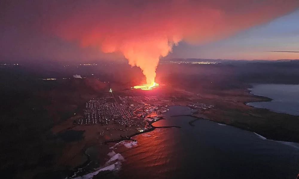
The Reykjanes Peninsula in south-west Iceland is where the Mid-Atlantic Ridge comes onshore. Since late 2023 the Sundhnúkur crater row (Sundhnúkagígar), just north of the fishing town Grindavík, has opened again and again as basaltic fissure eruptions. Iceland also sits above the Iceland hotspot, so the peninsula is a double-cause landscape: a divergent plate boundary thickened by a mantle plume. Into 2026 the Icelandic Meteorological Office (IMO) was still measuring magma accumulation and ground uplift under Svartsengi. That is not Hawaiian intra-plate volcanism and not a Sicilian stratovolcano.
Key highlights
- What it is: Fissure eruptions on the Reykjanes Peninsula — Mid-Atlantic Ridge (divergent) plus the Iceland hotspot.
- Where: Sundhnúkur / Sundhnúkagígar crater row, north of Grindavík; about 63.88° N, 22.14° W.
- Series: Repeated outbreaks since 18 December 2023 after the 2021–23 Fagradalsfjall unrest ended ~800 years of quiet on the peninsula.
- 2026 status: IMO reported continued uplift and magma storage under Svartsengi (about 27.5 million cubic metres accumulated since mid-July 2025, in the 9 June 2026 note). A new dike and possible eruption remained the most likely scenario.
- Landform: Crater row and lava fields, not a single steep cone.
- Exam hook: Divergent-boundary basalt versus Kīlauea (hotspot shield, no boundary) and Etna (convergent stratovolcano).
- Official monitor: Icelandic Meteorological Office.
Where is the Reykjanes–Sundhnúkur system?
Reykjanes is the south-western peninsula of Iceland, the landward continuation of the Reykjanes Ridge segment of the Mid-Atlantic Ridge. The 2023–26 vents lie on the Sundhnúkur crater row between the hills Sýlingarfell and Stóra-Skógfell, a few kilometres north of Grindavík. Keflavík International Airport and Reykjavík sit on the same peninsula and capital region, which is why a local fissure becomes an international news item.
Svartsengi is the geothermal area and power plant just inland of Grindavík. IMO uses Svartsengi as the name of the magma reservoir that inflates between eruptions. The Blue Lagoon spa sits in the same industrial-geothermal complex. When a dike runs south, the risk is to the town, the plant and the road grid, not to a remote ice cap.
| Fact | Detail |
|---|---|
| System | Sundhnúkur crater row (Sundhnúkagígar), Reykjanes Peninsula |
| Country | Iceland |
| Coordinates (approx.) | 63.88° N, 22.14° W |
| Nearby town | Grindavík |
| Reservoir / plant | Svartsengi |
| Plate setting | Divergent Mid-Atlantic Ridge + Iceland hotspot |
| Plates | North American and Eurasian |
| Eruption style | Basaltic fissure eruptions, lava fields |
| Series start (this crater row) | 18 December 2023 |
| Ninth Sundhnúkur eruption | 16 July–5 August 2025 (IMO) |
| 2026 signal | Uplift and magma accumulation under Svartsengi |
| Observatory | Icelandic Meteorological Office |
Write Reykjanes Peninsula + Sundhnúkur + Grindavík. “Reykjanes” is the district-scale name; “Sundhnúkagígar” is the vent alignment. A question that places the 2023–26 fissures under Vatnajökull or at Eyjafjallajökull is mixing three different Icelandic systems.
What is a fissure eruption on a divergent boundary?
A divergent plate boundary is where two plates move apart and new crust forms. In the oceans that boundary is a mid-ocean ridge. Iceland is the rare place where the ridge stands above sea level. The North American Plate lies to the west, the Eurasian Plate to the east. As they separate, the crust cracks. Magma uses those cracks. The surface expression is often a fissure: a linear vent, metres to kilometres long, that feeds a sheet of basalt rather than a single summit crater.
Sundhnúkagígar means the crater row at Sundhnúkur. A crater row is what a fissure leaves behind: a line of scoria cones and pits. Each new outbreak may open a slightly different segment of the same weakness. That is why IMO talks about “the Sundhnúkur crater row” as a system, not about “Mount Reykjanes” as if it were Fuji.
Iceland’s second ingredient is the Iceland hotspot (mantle plume). The plume supplies extra melt and extra crustal thickness, which is why the ridge is subaerial here and not a mid-ocean valley. Reykjanes is therefore a double-cause example in the NCERT sense: boundary type plus plume. Kīlauea is plume without a boundary. The Mid-Atlantic Ridge south of Iceland is boundary with a weaker plume signal. Do not drop the plume from Iceland, and do not add a trench.
Basalt on a ridge is usually tholeiitic and fluid. Flows build lava fields, close roads, and can dam against barriers. They do not automatically build a stratovolcano. After several years the peninsula looks like a black pavement with cones strung like beads. That landscape is the exam image for divergent volcanism.
How the 2023–26 series actually ran
Reykjanes had been volcanically quiet for about eight centuries before Fagradalsfjall erupted in 2021, with further activity in 2022–23. That was the first modern warning that the peninsula had re-entered an eruptive epoch. The Sundhnúkur chapter began on 18 December 2023, after an autumn earthquake swarm and a magma intrusion that forced the evacuation of Grindavík. From then through 2025, IMO counted a sequence of fissure eruptions on the same crater row.
IMO’s own wrap-up of the ninth Sundhnúkur eruption is the last numbered outbreak that should appear in a careful note. That eruption began on 16 July 2025 and was declared over on 5 August 2025. Tremor and crater activity stopped; a new hazard map still warned that fresh lava crust can collapse and that gas can linger. Uplift at Svartsengi resumed within days. IMO’s line then, and again in 2026, was that magma was still arriving.
Do not invent a tenth episode number or a 2026 vent-by-vent diary that official notices do not give. The Places in News card treats the system as ongoing into 2026 because the crisis did not end when the ninth fissure froze. On 9 June 2026 IMO wrote that uplift and magma accumulation under Svartsengi remained stable, and that model calculations showed about 27.5 million cubic metres of magma stored since around mid-July 2025. On 3 July 2026 it repeated the same story: accumulation rate steady; the most likely next step a new dike intrusion and possibly an eruption.
That is how a divergent system looks between outbreaks. The ground rises as the reservoir fills. Seismicity may stay moderate. Then a dike shoots sideways, the surface drops, and a crack opens. Tourism copy that says “Iceland’s volcano is erupting every week in 2026” is not what IMO published. The accurate sentence is: the Sundhnúkur–Svartsengi system stayed in an eruptive crisis through 2026, with magma still accumulating after the 2023–25 fissure series.
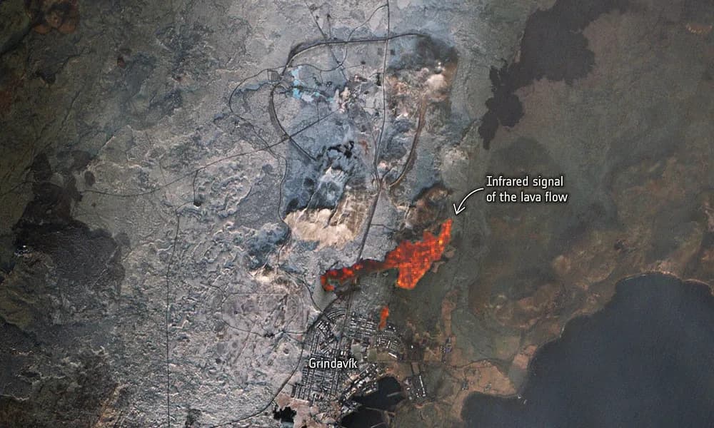
Grindavík’s story is the human geography. A small coastal town sat on the south side of an inflating reservoir. Earthquakes cracked pipes and houses in late 2023. Lava later overran parts of the outskirts and threatened the road to the Blue Lagoon and the Svartsengi plant. Barriers were built. The plant kept producing power and water for the peninsula through several scares. For GS-3 this is infrastructure-next-to-a-fissure, not ash-over-a-metropolitan-airport (Etna) and not a closed national-park crater (Kīlauea).
Mid-Atlantic Ridge versus the other two 2026 volcanoes
The value of writing Reykjanes beside the other two 2026 eruptions is the plate-boundary triad.
Kīlauea is intra-plate. The Pacific Plate is not splitting at Hawaiʻi and not diving into a trench there. A plume makes a shield. Fountains rise from Halemaʻumaʻu and pour basalt onto a crater floor. USGS HVO numbers those pulses; episode 53 on 12–13 August 2026 is the dated one.
Mount Etna is convergent. Africa and Eurasia close the Mediterranean. The mountain is a stratovolcano. INGV talks about Voragine, Strombolian explosions and ash over Catania. The landform is a cone you can see from the city.
Reykjanes is divergent, with a plume on top. IMO talks about dikes, crater rows, Svartsengi inflation and Grindavík. The landform is a crack. If an MCQ offers “all three 2026 volcanoes are Ring of Fire stratovolcanoes,” every clause is wrong.
| Question the examiner is really asking | Reykjanes answer |
|---|---|
| What kind of boundary? | Divergent (Mid-Atlantic Ridge) |
| Extra melt source? | Iceland hotspot |
| Vent geometry? | Fissure / crater row (Sundhnúkur) |
| Magma? | Basalt |
| 2026 official signal? | Magma accumulation and uplift at Svartsengi (IMO) |
| Nearby settlement? | Grindavík |
| Not to be confused with | Eyjafjallajökull 2010; Kīlauea; Etna |
India’s teaching parallels are imperfect but usable. The Mid-Indian Ridge is the same class of divergent boundary, only submarine. The Deccan Traps are a plume province without a spreading ridge at the surface. Barren Island is an arc volcano. Reykjanes is the place where ridge and plume can be named in one sentence without cheating.
How the Icelandic Met Office watches a ridge
IMO is Iceland’s weather, earthquake and volcano agency. On Reykjanes it combines GNSS GPS, InSAR satellite radar, seismometers, gas sensors and visual / drone observations. The operational objects are uplift rate, magma volume in the model, dike direction, and a colour hazard map for Grindavík, Svartsengi and the tourist zone.
A dike intrusion is a sheet of magma that injects into a crack without necessarily reaching the air. Several 2023–25 crises began as dikes; only some of them erupted. That is why IMO’s July 2026 language was careful: accumulation now, intrusion later, eruption possible. For Prelims, “dike” is the word to attach to Reykjanes. HVO’s word for Kīlauea is “episode” at a summit vent. INGV’s word for Etna is “paroxysm” or Strombolian phase at a crater.
Aviation is a smaller daily story here than at Etna, unless a fissure becomes unusually explosive. The 2010 Eyjafjallajökull ash crisis was a different volcano, ice-capped, with meltwater and a fine ash plume over Europe. Copy-pasting 2010 onto Sundhnúkur is a frequent current-affairs mistake. Reykjanes 2023–26 has been a lava and gas crisis: sulfur dioxide haze, closed roads, evacuated town, threatened power plant.
Why this matters for UPSC
Prelims. Iceland; Reykjanes Peninsula; Sundhnúkur / Sundhnúkagígar; Grindavík; Mid-Atlantic Ridge; North American–Eurasian plates; hotspot as the second cause; fissure eruption; IMO. False statements: Iceland is on a convergent boundary; Reykjanes is a stratovolcano like Etna; the 2023–26 vents are under a glacier; this is the 2010 Eyjafjallajökull eruption.
GS-1. Use Reykjanes to define seafloor spreading that you can walk on. Then place it in the 2026 triad: hotspot-only Hawaii, convergent Sicily, divergent-plus-plume Iceland. That paragraph scores because it shows classification, not because it lists dates.
GS-3. Evacuation of a town sitting on an inflating dike path; protection of a geothermal plant; lava barriers; gas pollution. India’s geothermal and mid-ocean-ridge exposure is limited, so the case is imported. The transferable idea is infrastructure sited on an active rift.
Map. South-west Iceland, peninsula pointing toward the Reykjanes Ridge, Grindavík on the south coast, Reykjavík to the north-east, Keflavík airport on the western end. Do not put Sundhnúkur in the highlands or next to Vatnajökull.
This explainer sits with the Places in News timeline.
Facts that are easy to mix up
Reykjanes versus Eyjafjallajökull. Eyjafjallajökull is the 2010 ice-capped ash volcano that closed European airspace. Sundhnúkur is a 2023–26 coastal fissure system. Different mountain, different hazard.
Fagradalsfjall versus Sundhnúkur. Fagradalsfjall (2021–23) reopened the peninsula. Sundhnúkur (from December 2023) is the crater row that threatened Grindavík. Both are Reykjanes; they are not the same vent.
Hotspot-only versus ridge-plus-hotspot. Hawaii is the first. Iceland is the second. Saying “Iceland is just like Hawaii” drops the plate boundary.
Ninth eruption versus 2026. IMO numbered nine Sundhnúkur eruptions through 5 August 2025. 2026, in official notes available for this explainer, is the inflation chapter. Do not mint a new episode number.
Fissure versus stratovolcano. A line of craters is not Etna. If the option says “composite cone on Reykjanes,” it is wrong.
Grindavík versus Reykjavík. Grindavík is the small town next to the vents. Reykjavík is the capital, tens of kilometres away. Tremors can be felt in the capital; the lava is a peninsula problem.
Prelims snapshot
| Question type | Answer to lock |
|---|---|
| Country / peninsula | Iceland / Reykjanes |
| Vent name | Sundhnúkur / Sundhnúkagígar |
| Nearby town | Grindavík |
| Boundary | Divergent Mid-Atlantic Ridge |
| Extra cause | Iceland hotspot |
| Plates | North American and Eurasian |
| Style | Basaltic fissure eruptions |
| Series from | 18 December 2023 |
| 2026 IMO signal | Magma accumulation / uplift at Svartsengi |
| Contrast | Kīlauea (hotspot shield); Etna (convergent stratovolcano) |
Frequently asked questions
What is the Reykjanes eruption in 2026?
It is the continuing volcanic crisis on Iceland’s Reykjanes Peninsula, centred on the Sundhnúkur crater row north of Grindavík. Fissure eruptions have repeated since 18 December 2023. In 2026 the Icelandic Met Office reported ongoing magma accumulation and ground uplift under Svartsengi, with a new dike and possible eruption as the most likely next step.
Why does Iceland have volcanoes if it is not on the Ring of Fire?
Iceland sits on the Mid-Atlantic Ridge, where the North American and Eurasian plates spread apart, and above the Iceland hotspot. Both supply melt. The Pacific Ring of Fire is a subduction belt. Reykjanes is a spreading-ridge story, not an arc-volcano story.
What is Sundhnúkagígar?
Sundhnúkagígar is the crater row at Sundhnúkur — a line of vents created by fissure eruptions on the Reykjanes Peninsula. It is the named system for the outbreaks that began on 18 December 2023 and threatened Grindavík, Svartsengi and nearby roads.
Is Reykjanes a shield volcano like Kilauea?
No. Kīlauea is a central-vent shield over a hotspot with no plate boundary. Reykjanes erupts from linear fissures on a divergent ridge. Both produce basalt; the plumbing and the landform differ. Etna is the steep convergent cone in the same 2026 set.
What did the Icelandic Met Office say in 2026?
IMO’s 9 June 2026 note said uplift at Svartsengi was continuing and that about 27.5 million cubic metres of magma had accumulated since mid-July 2025. The 3 July 2026 update said the accumulation rate was steady and that a future dike intrusion, possibly with an eruption, remained the most likely scenario.
Did the ninth Sundhnúkur eruption happen in 2026?
No. IMO recorded the ninth eruption from 16 July to 5 August 2025. Treat 2026 as the post-ninth inflation phase of the same ongoing system, unless a later official notice names a new outbreak.
What should UPSC aspirants remember about Reykjanes?
Iceland; Reykjanes Peninsula; Sundhnúkur crater row; Grindavík; Mid-Atlantic Ridge; North American–Eurasian divergence; Iceland hotspot; fissure basalt; IMO; series from December 2023; 2026 magma accumulation at Svartsengi; contrast with Kīlauea and Etna.